 Almalyk Mining and Metallurgical Complex Joint Stock Company
-
Call-center
+998 78 141 90 09 -
Helpline
+998 71 619 23 33
-
Call-center
+998 78 141 90 09 -
Helpline
+998 71 619 23 33
Kalmakyr mining administration
Kind of activity:
Mining. Quarry "Kalmakyr": copper-porphyry ores of the deposit. The main industrial value of the ores of the Kalmakyr deposit is copper, molybdenum, precious metals, as well as sulfur, selenium, tellurium, and rhenium. The field "Kalmakyr" is worked out by an open method, the system of development is transport with the removal of rock to external dumps.
Sary-Cheku quarry: the ores of the deposit are similar to the ores of Kalmakyr, but with a higher copper content in the ore. The Sary-Cheku deposit is mined in an open pit, the development system is transport with the removal of rock to external dumps.
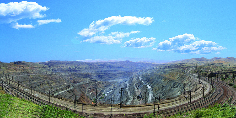
"Kalmakyr" Mine
The Kalmakyr field is located in very favorable geographic and economic conditions. It is located in the Almalyk-Angren industrial region with a developed mining and metallurgical industry.
The Kalmakyr Mine Administration is one of the largest mining enterprises. On its basis, a copper processing plant and the first copper smelter in Central Asia were built. The construction of the quarry began in 1954, and on July 1, 1959, an act was signed on the commissioning of the first stage of the Kalmakyr mine. Since that time, its systematic exploration and exploitation has been carried out. The first development project for the deposit was drawn up by the Leningrad Institute "Gipruda", then the design of the Kalmakyr mine was transferred to the Moscow Institute "Giprotsvetmet" and in 1960 the Institute developed an expansion project. Over the past years, the Institute has periodically corrected the project for the development of the deposit.
At that time, the excavators of the Ural Heavy Machinery Plant - SE 3 with a three-cubic bucket were used as loading equipment, and vehicles of various carrying capacities from three to ten tons were used to haul the rock to the dump. In 1962, four dump dead ends were in operation on the lower tiers of the Nakpaisai dumps, and one on the upper tier. In the quarry, mining operations were carried out in two mining areas. Rock excavators EKG-8 have been working at the mine since 1963, heavy trains with ore and rock were transported by electric locomotives with a grip weight of 150 tons. By the end of 1965, all cable-percussion drilling machines were replaced by roller-cone drilling machines of the VSV-3, BSSH 2M type.
In the early seventies, a new change of mining and transport equipment begins. Skillfully, using the capabilities of mining technology and the achievements of mining science and practice, the mine specialists constantly improved the technology of production processes.
Sedimentary, igneous (igneous), and metamorphic rocks take part in the geological structure of the deposit. Sedimentary rocks are represented by yellow sandstones and gray sericitized limestones. Igneous rocks - quartz porphyries, granodiorite - porphyries, syenite - diorites, diorites. Metamorphic rocks are mainly represented by secondary quartzites after igneous rocks.
The ores of the deposit are vein-disseminated and confined to the exocontact zone of stocks of granodiorite-porphyry, intruding rocks of the syenite group. Rocks and ore have an intense network of cracks that break the massif into small and large blocks. The coefficient of rock strength according to the scale of prof. M. M. Protodyakonova ranges from 10 to 16.
The project adopted a transport development system with removal of overburden to external dumps. The movement of the front of work in the quarry is parallel, when switching to a permanent spiral exit, it is fan-shaped with a turning point of the ledges at the exit trench.
The Kalmakyr quarry is pear-shaped with a thickening in the eastern part. The horizons above 680 m are L-shaped with parallel advancement of the faces, and the horizons below 680 m are U-shaped. Currently, 24 ledges have been cut at the mine, 16-17 are constantly in operation. The height of the working ledges is 15-22.5 meters. The minimum width of working platforms is 40-60 m, and the length of the working front of the excavator on the upper horizons is 800-1000 m, on the lower levels 600-800 m. The height of the ledges from the top mark to the horizon 670 m – 22.5 m, below – 15 m is predetermined by the used loading equipment.
At present, the quarry is deepening by 5-6 m per year, and the speed of advancement of the work front is 90-100 m.
Road transport is used on the upper horizons of the quarry, in areas of elevation +760 m and above, as well as when carrying out capital and cutting trenches when opening new horizons.
Rail transport is used to transport overburden to railway dumps and ores to a processing plant.
Drilling of blast holes in the mine is carried out by drilling rigs SBSh-250 MN-32 – 19 pcs.
Wells are drilled with cone bits with a diameter of 244.5 mm.
Loading of rock mass into vehicles is carried out by cyclic excavators of the type - a direct mechanical shovel. Currently, excavators of the EKG-20, EKG-15, EKG-12.5, EKG-10, EKG-8I, EKG-6.3, EKG-5U, EKG-5A, EKG-4.6 brands with a bucket capacity are used from 4.6 m3 to 15 m3.
Overburden and ores are transported by broad gauge electrified railway transport. Usually 28-30 train locomotives with 13 dump cars are in operation.
Locomotive trains work in a quarry on an open cycle, trains are not assigned to certain excavators, and the dispatcher manages the supply of trains for loading.
On each working horizon, one railway track was laid with one transport exit from the working horizon. The exchange of trains is carried out outside the work front.
Transportation of overburden from the upper horizons (760m and above) to the dump and ores to the transfer hubs is carried out by road.
The production area for the acceptance of overburden rock No. 2 is located to the west of the mine wall at a distance of about 10 km, which hosts waste rock, off-balance and balance ore of low grade.
The power supply of the Kalmakyr mine is carried out from the main stepdown substation GPP No. 1, No. 2, No. 3, No. 7. The power supply scheme is combined: excavators and drilling rigs are fed with stationary power lines of 6 kV, which are carried out on wooden or concrete supports with wire A-50, A-35.
The inflow of water into the quarry comes from 3 sources:
Atmospheric precipitation (in the autumn-spring period)
Fissure waters of Paleozoic rocks
Groundwater of river valleys
To determine the MPC level (maximum permissible concentrations), measurements are carried out annually at the mine by specialists from the Central Analytical Laboratory of JSC Almalyk MMC.
Sary-Cheky
The structure of the mining department "Kalmakyr" also includes the Sary-Cheku quarry, located in the Saukbulak ore field to the southeast of the city of Almalyk, on the northern slope of the Kuraminsky ridge. The deposit was discovered in 1932 by Batalov A.B. during the cuprometric survey under the guidance of Korolev A.V.
At present, the Sary-Cheku deposit is being mined by a quarry.
The Sary-Cheku copper-molybdenum deposit is located at elevations of 1040-1580 m in the middle reaches of the Sauk-Bulak River. The field is connected by an asphalt road 26 km long with the city of Almalyk. The Izvestkovaya station is located on the Akhangaran-Svintsovaya railway line and is located 14 km from the quarry.
In economic terms, the Sary-Cheku field is in favorable conditions. It is located in the well-developed Almalyk mining region, where there is a base of operating lead-zinc and copper mining and processing and metallurgical enterprises.
The Sary-Cheku deposit was put into operation in May 1974. In May 1981, the State Reserves Committee of the USSR approved new conditions by protocol No. 1582 dated 08.05.81.
The area of the ore field is limited from the northwest by the Miskan fault, from the northeast by the Urgaz River and from the south by the axis of the Kuramin Range.
The relief of the area of the Sauk-Bulak ore field has a rugged character, where the absolute marks range from 700 to 1000 m, and in the southern part from 900 to 2000 m.
The area is complicated by highly developed folding. The Sary-Cheku deposit is located in the hanging side of the large Miskan fault and is composed mainly of igneous rocks.
All rocks of the deposit are subject to ore mineralization, however, industrial concentrations are confined not only to crushed quartz porphyries and “pink” granodiorite porphyries. The nature of mineralization is vein-disseminated, stockwork type. The mineralogical composition of ores is as follows: pyrite, chalcopyrite, molybdenite.
The rocks composing the deposit have been altered by hydrothermal processes. Seritization and silicification processes have received the greatest development. Bulk density of rocks and sulfide ores - 2.6 t.m3. Bulk density of oxidized ore is 2.5 t.m3.
Mining and geological conditions are favorable for open pit mining of the Sary-Cheku deposit.
The development of mining operations on overburden and mining is planned in the southeast direction. The development of a quarry is carried out by ledges with the excavation of the rock mass by stopways. The number of ledges in development is 8. The slope angle of the working ledge is taken equal to 800.
The project adopted a transport development system with removal of overburden to external dumps using vehicles. The height of the ledges is 15 m, the width of the working platforms is from 20-60 m.
Drilling of blast holes in the quarry is carried out, as well as at the Kalmakyr mine, by drilling rigs SBSh-250 MN-32 in the amount of 4 units.
Wells are drilled with cone bits.
Loading of rock mass into vehicles is carried out by cyclic excavators of the type - a direct mechanical shovel. Currently, excavators of the EKG-10, EKG-8-i, EKG-5 brands with a bucket capacity of 10, 8 and 5 m3 are used.
Transportation of overburden to dumps and ore to the transshipment hub is carried out by BelAZ road transport with a carrying capacity of 130 tons. Road transport operates in two shifts, 12 hours a day, seven days a week. The average distance of haulage of the rock mass to the ore warehouse is 5.0 km, to the overburden dumps 3 km. 8-12 cars work per shift.
Various bulldozer equipment is used in mining, which is allocated for quarries with UAT. Powerful bulldozers are used to clear ledges, and graders are used to repair roads.
The power supply of the Sary-Cheku quarry is carried out from the main stepdown substation GPP 35/6 from two transformers with a capacity of 2500 kVA through four feeder lines. The power supply scheme is combined: stationary power lines 6 kV, made with A-35 wire, go to excavators and drilling rigs, then at working horizons, stationary power lines turn into mobile power lines, which are made on wooden or concrete supports with A-35 wire. Mobile power lines are connected to adventure points and are connected to excavators through a cable of the KGE type.
Director: Isakov Mkhamadamin Mamadumarovich.
Phone: (+998 71) 141-90-09
E-mail: info@agmk.uz
